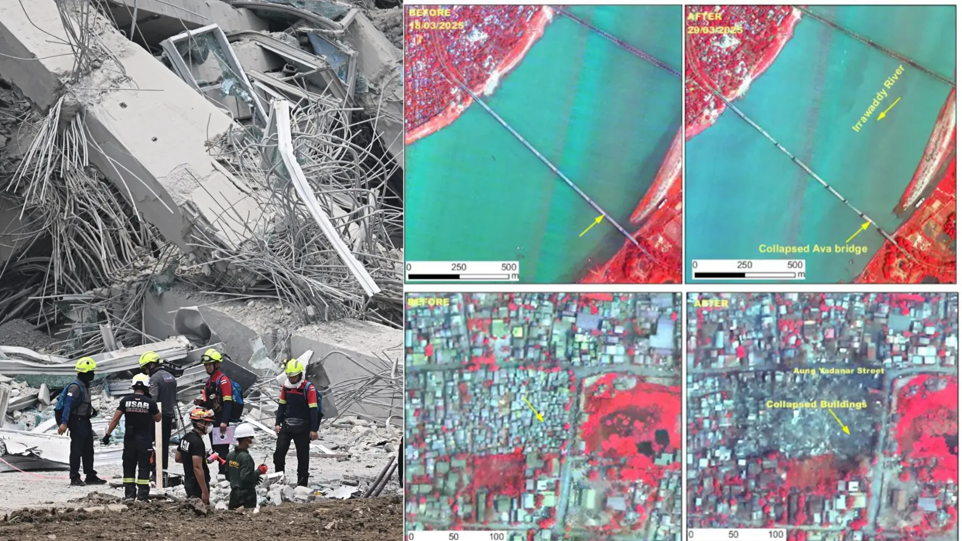
Indian Space Research Organisation (ISRO) has published satellite images of the extensive damage caused by the 7.7 magnitude earthquake that hit Myanmar and shook bordering nations on Friday.
High-Resolution Imaging by Cartosat-3 of ISRO
Employing its most advanced Earth imaging satellite, the Cartosat-3, which has a camera resolution of less than 50 centimetres, ISRO was able to take pictures from a height of 500 kilometres above the Earth. The photos show extensive damage, such as the collapse of an enormous bridge across the Irrawaddy River, destruction of Mandalay University, and collapse of the Ananda Pagoda.
ISRO Uses A Rarely Advanced Satellite Named Cartosat-3
As per ISRO, Cartosat-3, which was launched in 2019, is a third-generation agile advanced Earth imaging satellite. ISRO issues images from this highly advanced satellite very rarely.
The National Remote Sensing Centre, which is part of ISRO, said that post-disaster images of Cartosat-3 were taken on Saturday over Mandalay and Sagaing in Myanmar. Cartosat-3 data from March 18, taken over the same region, were also utilised for cross-comparison and damage assessment. Extensive damage to infrastructure in Mandalay city was noticed.
The Earthquake and Its Aftermath
A 7.7-magnitude earthquake hit Myanmar on Friday and was followed by a powerful aftershock with a magnitude of 6.4. The epicentre occurred at a depth of 10 km along the Sagaing-Mandalay border. Mandalay, the country’s second largest city, has been severely hit.
The earthquake also affected the Myanmar capital, Naypyidaw, and other areas, causing infrastructure, roads, and residential buildings to collapse. The Earthquake was not only felt in Myanmar but also in neighboring countries. The Earthquake was felt in areas such as northern Thailand, where some areas experienced damage.
Widespread Damage in Mandalay and Sagaing
Satellite imagery reveals extensive damage in Mandalay. The Images show prominent landmarks like Sky Villa, Phayani Pagoda, Mahamuni Pagoda, Ananda Pagoda, and the University of Mandalay being completely or partially destroyed.
In the city of Sagaing, the Ma Shi Khana Pagoda, some monasteries, and other structures were also badly damaged.
Collapse of the Historic Ava Bridge
The earthquake resulted in the collapse of the historic Ava (InnWa) Bridge spanning the Irrawaddy River, off Inn Wa City. Flood plains of the Irrawaddy River also exhibited cracks and related liquefaction in the satellite imagery.
Seismic Activity and the Sagaing Fault
ISRO’s damage assessment report pointed out that Myanmar is situated close to the convergent boundary between the Indian and Eurasian plates. Wherein the Indian Plate has a northward movement of approximately 5 cm per year.
Furthermore, Myanmar is located close to a number of minor fault zones. These fault zones include the Sagaing Fault, a major active strike-slip fault that passes through central Myanmar. The earthquake was probably triggered by the release of stress that had built up along the Sagaing Fault or its secondary faults. India was among the first nations to send rescue teams and offer support to Myanmar following the disaster.


