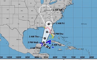
Tropical Storm Helene formed on Tuesday in the Caribbean Sea and is projected to intensify into a major hurricane as it moves toward the US. Forecasters predict that the storm will strengthen rapidly, potentially reaching Category 3 status as it approaches the Gulf Coast. Currently, it is 170 miles southeast of Cuba with winds at 45 mph.
Florida Prepares for Impact
Florida Governor Ron DeSantis declared a state of emergency in 41 counties ahead of Helene’s arrival. Evacuation orders are expected, and residents are urged to prepare for power outages, flooding, and dangerous storm surges. The National Hurricane Center has issued hurricane watches for parts of Florida’s coastline, including Tampa Bay, and a tropical storm warning for the Florida Keys.
Forecasters Warn of Rapid Intensification
According to the National Hurricane Center, Helene is moving over deep, warm waters that will fuel its rapid strengthening. “Conditions look favorable for intensification,” said hurricane specialist Lisa Bucci. Heavy rain and high waves have already hit the Cayman Islands, with the storm predicted to bring up to 12 inches of rain to Cuba and Mexico’s Yucatán Peninsula.
Widespread Storm Surge and Flooding Threats
Helene’s large size means its effects will be felt far beyond its center. The storm is expected to cause storm surges of up to 15 feet along parts of Florida’s Gulf Coast, with warnings in place from Tampa Bay to Charlotte Harbor. Inland areas in the southeastern US, including Tennessee and Kentucky, may also experience heavy rainfall and flooding.
Cuba and Mexico Brace for Impact
Parts of Cuba and Mexico are under hurricane and tropical storm watches. In Cuba, where 600,000 people are already facing water shortages, residents are preparing for significant rainfall and power outages. The storm is forecast to pass between Cuba and Mexico’s Yucatán Peninsula before moving northward into the Gulf of Mexico.
NOAA Predicts Active Hurricane Season
Helene is the eighth named storm of the Atlantic hurricane season, which runs from June to November. The National Oceanic and Atmospheric Administration (NOAA) has forecast an above-average season, with 17 to 25 named storms and up to seven major hurricanes.


