Tropical Storm Francine, previously a Category 2 hurricane, has weakened but continues to cause widespread disruption across the southeastern U.S. Heavy rainfall, flooding, and power outages have been reported in Louisiana, Mississippi, Alabama, and the Florida Panhandle. Here are the latest updates on Francine’s effects.
1. Made Landfall as a Hurricane
Francine made landfall in Terrebonne Parish, Louisiana, at 5 p.m. local time on Wednesday as a Category 2 hurricane. The storm brought 105 mph winds, causing widespread damage across the state.
2. Weakened to a Tropical Storm
By Thursday morning, Francine had weakened to a tropical storm with sustained winds of 50 mph. As of 8 a.m. ET, it was located 30 miles south of Jackson, Mississippi, moving north at 12 mph.
3. Current Position
According to the National Hurricane Center (NHC) Francine was positioned about 20 miles northwest of New Orleans and moving northward into southern Mississippi at 14 mph.
4. Power Outages
Over 400,000 customers in Louisiana, Mississippi, and Alabama were left without power due to the storm’s strong winds and flooding. Several areas experienced grid damage and disruptions.
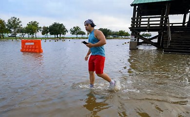
5. Flood Warnings
Around 14 million people are under flood warnings across southeastern Louisiana, southern Mississippi, Alabama, and the Florida Panhandle. The New Orleans area was particularly hard-hit, with over 7.33 inches of rain recorded at the airport.
6. Tornado Watch Issued
A tornado watch is in effect for parts of southern Alabama and the Florida Panhandle until 1 p.m. CDT. Isolated tornadoes are expected in these regions throughout the day.
7. Storm Surge Threat
Dangerous storm surges of 4 to 6 feet are predicted along the coastlines from Louisiana to Mississippi, with 3- to 5-foot surges expected between Morgan City, Louisiana, and the Alabama border.
8. Flash Flooding in Mandeville
The city of Mandeville, near Lake Pontchartrain, experienced flash flooding, especially in the Greenleaves neighborhood. Residents were warned of rising waters near homes as Francine moved north.
9. Flood Risks in Alabama
Northern and central Alabama face significant flood risks, with rainfall expected to reach up to 10 inches. The NWS highlighted these areas as having the highest threat for flash flooding.
10. Public Safety Warnings
Despite rain subsiding in New Orleans by late Wednesday, residents are urged to avoid flooded roads, which may hide hazards such as sewage or downed power lines.