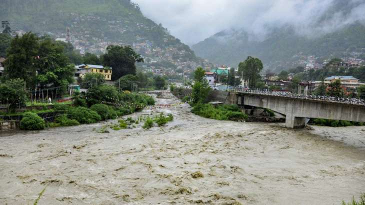
Sikkim Urja (formerly known as Teesta Urja), the largest hydroelectric power project in Sikkim, has suffered extensive damage in the wake of a flash flood that occurred on Tuesday night. The dam and the bridge connecting the powerhouse were swept away, and the water levels in the Teesta River in Sikkim continued to rise on Wednesday. Sunil Saraogi, the executive chairman of Sikkim Urja Limited, revealed, “The dam located at Chungthang was completely washed away in just ten minutes shortly after midnight. Additionally, we witnessed the 200-meter-long bridge connecting to the powerhouse being carried away by the floodwaters. The entire powerhouse is now submerged underwater.”
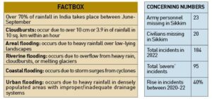
A cloudburst triggered the flash flood in the Teesta River that has led to at least 23 Army personnel and 20 civilians being reported as missing across the state as of Wednesday evening. According to a statement released by the Indian Army’s Eastern Command, certain establishments in the Lachen Valley have been impacted. The statement further explained that the release of water from the Chungthang dam resulted in a sudden and significant rise in water levels downstream, reaching anywhere between 15 to 20 feet. This surge has affected Army vehicles parked near Bardang, close to Singtam. As a result, 23 personnel are currently unaccounted for, and some vehicles are believed to be submerged in the slush. Search and rescue operations are currently in progress.
Sikkim experienced heavy rainfall throughout the night, after a cloudburst occurred over Lhonak Lake in northern Sikkim, causing it to overflow. This overflow contributed to an increase in water levels in the Teesta River, which flows through Sikkim and West Bengal before reaching Bangladesh.
On Wednesday, Prime Minister Narendra Modi took to X (formerly Twitter) and said he had spoken to Sikkim’s Chief Minister, Prem Singh Tamang, and assured him of support from the Central government.
“Spoke to Sikkim CM Shri @PSTamangGolay and took stock of the situation in the wake of the unfortunate natural calamity in parts of the state. Assured all possible support in addressing the challenge. I pray for the safety and well-being of all those affected,” PM Modi’s post read.
State administration yesterday issued a high alert for residents. Videos recorded and shared by local residents show roads that have been washed away and the Teesta River in spate. “Nobody has been injured but there has been significant damage to public property. Some people have also been reported missing in Singtam. Relief operations are on,” Chief Minister Prem Singh Tamang said during a visit to one of many affected areas. The India Meteorological Department has said Teesta is swollen after the lake in Sikkim’s Chungthang overflowed. “Low-lying areas such as Gazoldoba, Domohani, Mekhaliganj and Ghish may be affected. Please be alert,” an alert from the weather office said.
DAMAGE TO SIKKIM URJA
The 1,200 MW project on Teesta River is located at Chungthang and Mangan in the North Sikkim district and had begun making profits for the first time only last year. The Sikkim government has 60.08 percent share in the project, the valuation of which stands at around Rs 25,000 crore. A run-of-the-river scheme, it utilises the available gross head of 800 metres. All the generating units were successfully commissioned in February 2017.
At least 30 people have been reported missing and six bridges have been washed away in north Sikim since Tuesday night due to the flash floods. Saraogi said, “At 11:58 pm on Tuesday, we got information from the Indo-Tibetan Border Police (ITBP). Immediately, our team went to the dam to open the gates. Before they could open, the flash flood hit them, and they ran away to save their lives. There were 12 to 13 people in the team and they somehow got saved on the other side of the dam and they would be evacuated by ITBP by 2 pm on Wednesday.”
“We are unable to reach the powerhouse. The entire team is stranded, finding it difficult to communicate. Roads are closed. We don’t know the extent of damage in the powerhouse at Mangan. No one could reach the powerhouse as the bridge connecting the dam had gone. Fortunately, no one is inside the powerhouse as all have come out,” he continued. The project’s executive chairman further explained that the project was running 120 percent of its capacity utilisation. “The dam and the bridge have to be rebuilt and the rebuilding cost would run in thousands of crores rupees. The losses would be thousands of crores,” he added.
As per the current shareholding structure of the company, Sikkim Urja Limited is a State Government Enterprise with Sikkim’s state government being the largest shareholders, with 60.08 percent stake through its investment company, Sikkim Power Investment Corporation Limited. Earlier on Wednesday morning, officials said that three districts in Sikkim—Mangan (north Sikkim), Pakyong, and Gangtok (east Sikkim) had been hit by the flash floods.
Of the three, Mangan has been hit the worst. Officials also said that the water level in the River Teesta was expected to cross the danger mark “within a few hours”. Keeping this in mind, a flood alert has been issued for certain districts in both north Bengal and Bangladesh.

PAST INCIDENTS
As of July this year—the wettest in decades—India recorded a 40 percent rise in flashflood events over the past three years owing to global warming. The Central Government, had in July, citied a report from the Intergovernmental Panel on Climate Change (IPCC), and warned that similar such trends of inclement weather would continue in the future.
In the same month, several parts of northern India witnessed heavy rains and suffered damages from severe flooding. This year’s monsoon triggered flash floods, landslides and evacuations across large parts of the northern region. Several rivers, including the Ravi, Beas, Sutlej, Yamuna, and the Ganga, were in spate for extended durations of time. Videos of bridges, roads and even houses crumbling under the sheer force of raging waters went viral across the Internet.
In Delhi, an overflowing Yamuna breached the “high flood level” mark on July 12 for the first time in 45 years, according to the Central Water Commission. The waters of the Yamuna River reached the walls of the Taj Mahal for the first time since the floods of 1978. In Kota, Rajasthan, people posted videos of crocodiles in residential areas after heavy rains this week. In mid-July, a cloudburst led to a flash flood in Ladakh.
The worst-hit state this year has been Himachal Pradesh, which suffered three bursts of violent monsoon rains that triggered flash floods and landslides across the state between the onset of monsoon in mid-June to early September. Over 200 people lost their lives in the disaster and the state incurred thousands of crores of rupees of losses, largely in the form of infrastructural damages.
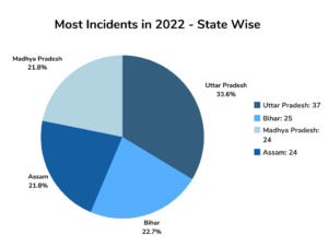
In 2020, India witnessed a total of 132 flashfloods. The number rose to 145 in the next year, according to the Union Ministry of Jal Shakti’s written reply in the Lok Sabha during the monsoon session. Last year, the country experienced a total of 184 flashfloods, of which 95 were “severe flooding”. Of these total 184 flashfloods recorded in 2022, Uttar Pradesh witnessed extreme flooding and reported 37 such incidents. This was followed by Bihar (25), Assam (24), and Madhya Pradesh (24). Warmer temperatures have lead to increased evaporation, which in turn leads to more moisture in the atmosphere. “This extra moisture leads to intense convection and intense rainfall leading to flashfloods,” the Ministry had said. “There has been a significant increase in extreme weather events, including intense rainfall activity, due to global warming. The frequency of localised heavy rainfall activity has also increased significantly due to which occurrence of landslides and flashfloods have increased,” the Ministry’s written reply in the Lok Sabha revealed.
LOSSES INCURRED
As per the National Disaster Management Authority (NDMA), India is highly vulnerable to floods. Out of the total geographical area of 329 million hectares (mha), more than 40 mha is flood-prone. The average annual flood damage in the 10-year period from 1996 to 2005 was Rs 4,745 crore as compared to Rs 1,805 crore, the corresponding average for the previous 53 years. It is also a continuously rising trend. Disasters caused by landslides and floods are common in India’s Himalayan north during the June-September monsoon season. Scientists say they are becoming more frequent as global warming increases. However, local experts say the current disaster is likely due to unplanned construction in this vulnerable region. “It is poor planning and governance that has led to this much damage,” said Anand Sharma, a retired meteorologist with the Indian Meteorological Department.
In 2021, economic losses from flooding in the country were a staggering $3.2 billion, as per The State of the Climate in Asia 2021 report. These losses can be attributed to a steep increase in population, rapid urbanization, deforestation, poor drainage systems, damming of rivers, and growing developmental and economic activities in the flood plains. Global warming, too, is a major contributor. Climate change is exacerbating extreme weather events in the country, making floods more frequent and intense.
