
Two significant events in the maritime domain passed us by recently without much flutter. Few days ago, Vice Admiral Vinay Badhwar, the Chief Hydrographer to the Government of India (GoI), was conferred the 2019 Alexander Dalrymple award by the United Kingdom Hydrographic Office (UKHO) in recognition of his outstanding contribution to Indian hydrography and across the wider Indian Ocean region.
Named after the first Hydrographer of the Admiralty, the recipients are selected for… “raising the standards of hydrography, cartography and navigation around the world”. Badhwar, the first Indian to get this award, acknowledged that “this would not have been possible without the support of colleagues in the National Hydrographic Department”.
His award is testimony to the excellence achieved by the Indian Navy, in hydrography, in a journey that began in the fifties, when the then Cdr Jal Cursetji was appointed as the first Chief Hydrographer to the GoI. The award can be considered a perfect gift for the late Cursetji, whose 101st birthday fell on 20 May. Admiral Cursetji, who went on to become the Indian Navy Chief in the mid-seventies, was a pioneer to whom India’s hydrography branch owes much of its growth and current repute, much in the same manner that nuclear energy owes to Homi Bhabha or space programme to Vikram Sarabhai.
Today, under the overhang of Covid-19, “solitude” has attained significance in our lexicon. But let’s talk about the people who combine solitude with solid substance. While soldiering is indeed a lonely profession, its maritime counterpart aka military seafaring is lonelier still and, within seafaring, hydrography is, arguably, the loneliest of all avocations.
The isolation, separation, sometimes even boredom and frustration faced by them as they soldier on relentlessly away from the arclight’s glare is not the stuff that would attract glamour or celebrity status, yet it would not be an exaggeration to say that the hydrographers are amongst the most important elements not only for a navy but also the nation. The “sea-blindness” that characterises our country has been spoken about and commented upon, in great deal, by informed analysts. Simply put, it translates into disregard or ignorance about what obtains at sea or how sea could influence events on land.
A collateral construct to this attribute of sea-blindness is “cartographic cataract”. As a nation we are also blissfully unaware of the importance of maps (and their maritime counterparts — the charts) and everything that they represent. The infinite variety of our land borders (IBL, LOC, LAC and AGPL) and the many lines that divide the subcontinent — Radcliffe, Durand, McMahon — named after various Englishmen should have led to some sort of curiosity and interest in how geography has shaped our recent history but, sadly, the general discourse in our country is diffident about such issues.
If this be the situation on land, the geography of seas and coasts, would axiomatically attract even lesser attention. While the Indian Navy makes valiant efforts to change the narrative at the grand strategic level it is the hydrographers — our chartmakers — who quietly, but efficiently, work to map our oceans. In some ways hydrography can be considered the “mother knowledge” (Saraswati Vidya) for any mariner. After all, to go beyond the wide yonder one needs some information and knowledge about the terrain.
One needs to know the currents and wind patterns, the contours and depths, the lay of the land and presence of dangers before setting out on a voyage. One can imagine the trepidation and foreboding with which the pioneer explorers of yore embarked on their ventures for they had no idea what to expect. Cartography was a natural adjunct to exploration and it is no wonder that at the heights of age of exploration in the 15th and 16th century, information on maps and oceans about the “East” was considered “classified” in Europe (particularly Portugal and Spain) and anybody who blurted out such intelligence could be punished with death.
One can also imagine what fate may have befallen Vasco da Gama if an Arab navigator called Ahmad Ibn Majid, as many historical accounts state, had not piloted his fleet across the Indian Ocean from Malindi in Kenya to Calicut in India in 1498. It was the intimate knowledge that Ibn Majid and other regional seafarers possessed that the Europeans harnessed and then used as a tool of power in their conquests that led to colonisation of the East.
It is also, perhaps, no mere coincidence that some of Charles Darwin’s theories of evolution and origin of species took shape during a survey voyage in the Atlantic of HMS Beagle in end 1831. Thus, one of the most important lessons that history offers is that cartography or charting the oceans is not merely about transportation or safe navigation but also about resource mapping (and exploration) and ownership. Once upon a time they unlocked the keys to empire, today they signify sovereignty.
The fledgling Indian Navy, at the dawn of independence, had realised this subtle power of hydrography, hence it was entirely fitting that some of our best officers like Cursetji volunteered for Hydrography and our first significant indigenous venture was the survey ship INS Darshak commissioned in 1964. Even as we celebrate the illustrious achievements of our designers and shipbuilders, it would also be fitting to raise a toast to the pioneering hydrographers. My own interest in what the surveyors did was engendered in 1988 when posted as the Navigating Officer of a Landing Craft (LCU 37) in Port Blair.
We were fully operational and a new ship to boot, hence sailed extensively all over the A and N islands, merrily beaching at several places. Since all the beachings involved survey which was the Navigator’s responsibility I would grandiosely set out in a Gemini (small rubber inflated craft) with a couple of poles, flags, hand-lead line with divers and the Navigator’s Yeoman (Navyeo) in tow. The ship would ultimately follow the path we had supposedly mapped and declared “safe”.
These were days before GPS and other modern accoutrements. While occasionally this exercise would elicit a bout of pomposity imagining myself to be like a latter-day explorer, more often than not it induced cold sweat and worry if I had got my soundings right. At such times, I marvelled about what the surveyors did and how they would go on unceasingly with accuracy and precision. One also came to admire the surveyors when going around and close to many of the small islands there.
Our sister ship LCU 31 had an erratic echo sounder, so we had to absolutely trust the charts that we had when we went up close, as we frequently had to. This absolute reliance on the accuracy of the charts made me realise how we often took the chartmakers work for granted. The interest in hydrographers’ work was further enhanced in my next tour of duty as a navigator of a mine sweeper in Mumbai. As anyone with nodding acquaintance with mine sweeping would know, the delineation of area cleared of mines and marking a swept channel requires precision in navigation, which posed a big challenge in those days.
One of the gizmos that seemed to answer our query was equipment called “trisponder” which apparently was being used by surveyors with great success. Somewhat analogous to the DGPS system of today, the equipment needed three or more widely dispersed shore stations being triggered by an afloat unit and the resultant ‘fix’ obtained giving accurate position. Needless to say, this was easier said than done and we had to burn much midnight oil to try and understand the whole thing and further, face many logistics challenges rigging the equipment ashore and hoping like hell that it would “beep” when interrogated.
The knowledge that hydrographers were doing this all the time without much murmur and with greater success only increased my admiration for them. My subsequent tenures did not involve much interaction with them but I slowly came to be interested in maritime history. One of the recurring themes here was the high value that mariners placed on chart and map information. At one level, the history itself was fascinating be it some of the events related above or nuggets such as the British were defeating the French in the eighteenth century battles using French charts because their own hydrographic office was established only in 1795 compared to the French who did so in 1720.
And, somewhat analogous to the situation wherein more soldiers are lost to the elements than to the enemy fire, the Royal Navy lost more ships to shipwrecks than enemy action which spurred the Admiralty to set up their survey agency. The contribution of Admiral Francis Beaufort, who was at the helm for 25 years in the middle of nineteenth century as the longest serving British hydrographer, was as much to the British colonial enterprise as it was to knowledge about the oceans of the world.
The other thing that fascinated me was that this enterprise seemed to be a combination of so many subjects such as mathematics, trigonometry, theoretical geography, astronomy, oceanography and meteorology. And yet in a serendipitous twist, the end results showed the charts and maps to be works of art in their representation, in the calligraphic style and the visual motifs. Maps of medieval times had a great deal of allegorical representation including of mythical birds, islands, kings and tribes that were supposed to inhabit different parts of the world and thus were like a colourful collage.
I fondly recollect a map I had picked up — for a princely sum of Rs 10 — showing the world in medieval times which was an artistic treat and displayed proudly in my drawing room. Modern charts are somewhat limited by the fact that such “creative licences” are not exercised but they are no less beautiful to look at. Thus, to me a chart or map represents the ultimate marriage of art and science. Growing in the service one also realised the immense possibilities and potentialities of hydrography in international defence cooperation.
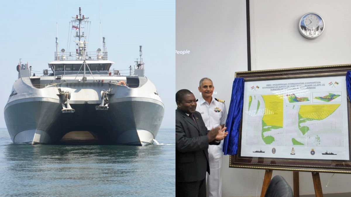
By this time, the Indian hydrography establishment had become the leading entity in the Indian Ocean Region (IOR) with renown both in terms of men and material. While we had a fairly formidable fleet of survey vessels many of the countries in the region had rudimentary or no capacities in this domain. Their dependence on old outdated charts not only increased the chances of maritime accidents (and disasters) but also prevented them from maximising their resource potential under the new UNCLOS regime. Cooperating with friendly foreign countries in this regard could result in a winwin situation.
Many pioneering initiatives had already been taken by our higher authorities to incorporate hydrography in the matrix of international cooperation. I was happy to contribute my two bits to it as the Defence Adviser in the Indian High Commission in Nairobi, Kenya, with East Africa as my area of responsibility. These ventures added to the earlier ones and other later endeavours in the IOR. Thus, over past few years, the National Hydrographic Office (NHO) has established its brand equity as a deliverer of high-quality service.
By adding to the capacities of the countries in our maritime neighbourhood we also have contributed to the greater common good that not only binds nations but also maritime communities. It is also a great achievement for a country that lost its independence due to its neglect of the sea and disregard of oceans to transform itself into a leading knowledgebased Navy with strong foundations in hydrography. Despite the many advances in technology, charting the seas will continue to have the human as its most vital cog.
There are no autopilots or fly by wire or fire and forget devices in their job, they have to get it right to the infinitesimal decimal point each and every time no matter how humdrum the task or how tedious the job. The hydrographers will continue to endure boredom, separation and isolation as they plough a lonely furrow. In wardroom banter and good-natured gossip, the “chartsevaks” are dismissed as nerds but guess what — the nerds are the new flavour of the world. Theirs is a life of solitude that breeds men of substance. From a “normal” general service guy a big hurrah to you all. Commodore Srikant Kesnur is a serving Indian Navy officer. He has done extensive research on maritime history.