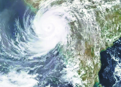
The low-pressure area over the southwest and adjacent west-central Bay of Bengal moved northeastwards and settled over the west-central and adjacent south Bay of Bengal by Thursday morning. The India Meteorological Department (IMD) has warned that cyclone ‘Remal’ is expected to form over the east-central Bay of Bengal by the morning of May 25.
According to the IMD, this cyclone will likely move northwards, reaching near the Bangladesh and adjoining West Bengal coasts by the evening of May 26, as a severe cyclonic storm with wind speeds of 100 to 120 kmph.
The IMD stated, “It is very likely to continue to move northeastwards and concentrate into a Depression over central parts of the Bay of Bengal by the morning of May 24. Thereafter, it is very likely to continue to move northeastwards, intensifying further into a cyclonic storm over the east-central Bay of Bengal by the morning of May 25.”
Roxy Mathew Koll, a climate scientist at the Indian Institute of Tropical Meteorology, had warned on Sunday that a low-pressure system would develop in the south Bay of Bengal during May 22-23.
Koll explained, “Sea surface temperatures in the south Bay of Bengal have been 2-3°C warmer than usual for quite some time. Persistently high sea surface temperatures provide a constant supply of heat and moisture, essential for cyclone formation. The Madden Julian Oscillation, an eastward traveling band of clouds, coupled with the winds and warm ocean waters, is moving to the south of the Bay of Bengal. These winds provide a rotational trigger for the cyclones to initiate.” He added, “The restricting factor could be a quick northward progression of the monsoon, suppressing the vertical formation of the cyclone.”
Koll noted that if this is the case, the low-pressure area will become a monsoon depression, bringing rain. “Otherwise, it could develop into a weak cyclone of short duration,” he said.


