
The Indian Meteorological Department (IMD) raised an orange alert warning for the coastal areas of Saurashtra and Kutch in Gujarat, anticipating the arrival of the severe cyclonic storm, “Biparjoy,” looming over the east-central and adjoining northeast Arabian Sea.
The menacing storm moved northward at a speed of 7 km/h in the past six hours and was positioned approximately 320 km southwest of Porbandar, 360 km south-southwest of Devbhumi Dwarka, and 440 km south of Jakhau Port, as of 8 a.m. Monday. IMD has warned of possible storm surges in Kutch, Devbhumi Dwarka, Porbandar, Jamnagar, and Morbi districts of Gujarat, which could see an inundation of 2-3 metres above normal tide levels during the storm’s landfall.
The districts of Kutch, Devbhumi Dwarka, Porbandar, Jamnagar, Morbi, Junagarh, and Rajkot in Gujarat are projected to face significant damage on June 15, with thatched houses possibly being destroyed, kutcha houses suffering extensive damage, and pucca houses also at risk. IMD has also noted the potential danger of flying objects during the storm.
IMD forecasts show that Cyclone Biparjoy will likely move northward until the morning of June 14 before taking a north-northeast direction, making landfall between Mandvi (Gujarat) and Karachi (Pakistan) near Jakhau Port (Gujarat) on the afternoon of June 15. The cyclone is expected to bring maximum sustained wind speeds of 125-135 km/h, with gusts up to 150 km/h.
Warnings of major infrastructural damage have been issued, including uprooted power and communication poles, damaged roads, flooded escape routes, and disrupted railway and overhead power lines. Agricultural areas could also be significantly impacted, with possible damage to crops, plantations, and orchards, and a likelihood of green coconuts falling and palm fronds tearing. Small boats may get detached from their moorings due to the turbulent sea conditions, severely affecting visibility.
An advisory has been issued to fishermen, advising them to return to the coast and refrain from venturing out to sea for the next five days. The IMD also forecasts squally wind speeds along the Gujarat coast that could reach up to 55-65 km/h on June 12 and increase to 60-70 km/h from June 13 to the evening of June 14.The IMD expects a gale wind speed of 65-75 km/h from the evening of June 14, intensifying to 120-130 km/h from the morning of June 15 for the following 12 hours. It also forecasts squally wind speeds of 55-65 km/h along the remaining districts of the Saurashtra coast on June 14 and 15.
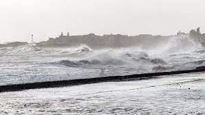
The IMD predicts rough to very rough sea conditions until the evening of June 14, with conditions escalating to high to phenomenal until noon on June 15. An improvement in sea conditions is expected after this period.