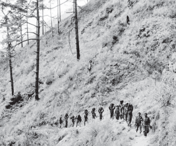
On the morning of 20 October 1962, the Himalayan frontier became the setting for one of the most consequential military setbacks in independent India’s history. Chinese forces launched a major offensive against Indian positions in two widely separated theatres: the North-East Frontier Agency (NEFA), now largely part of Arunachal Pradesh, and the high-altitude region of Ladakh. Indian troops, deployed across difficult terrain with serious disadvantages in equipment, logistics and operational preparedness, faced an offensive whose scale and intensity caught the country’s political and military leadership unprepared.
The attack shattered the prevailing belief that diplomatic engagement and shared Asian solidarity could help prevent a major conflict between India and China. It also exposed the consequences of leaving a disputed frontier inadequately defined while allowing political expectations to outpace military capabilities. The war lasted barely a month, but its consequences extended far beyond the battlefield, reshaping India’s defence establishment, its understanding of China and its approach to national security.
More than six decades later, 20 October remains an important date in Indian strategic history. It is not merely an anniversary of defeat, nor should it be reduced to a simple account of diplomatic betrayal. The conflict was the product of a complicated boundary dispute, deteriorating relations, competing territorial claims, decisions taken by political and military leaders, and a widening imbalance in preparedness. Understanding the war requires examining these factors together rather than searching for a single explanation.
The promise of friendship and the reality of the frontier
In the first years after independence, India sought to establish itself as an independent voice in international affairs. Under Prime Minister Jawaharlal Nehru, the country supported anticolonial movements, advocated peaceful coexistence and resisted rigid military alignments during the Cold War. China, following the Communist Revolution of 1949, was viewed by New Delhi as a major Asian neighbour with which cooperation could contribute to regional stability.
The political atmosphere was captured by the popular expression “Hindi-Chini Bhai-Bhai”, or Indians and Chinese are brothers. The slogan reflected the hope that two large Asian countries emerging from very different historical experiences could build a relationship based on mutual respect and resistance to external domination. Yet the warmth of diplomatic engagement concealed an unresolved geographical problem: the boundary between the two countries had never been comprehensively settled through a mutually accepted agreement.
The frontier stretched across mountains, plateaus and sparsely inhabited areas where maps, administrative practices and historical understandings did not always coincide. The dispute was especially significant in two regions. In the east, India regarded the McMahon Line as the boundary separating its territory from Tibet. In the west, China challenged India’s territorial claims in Aksai Chin, a high-altitude region that India considered part of Ladakh and that offered an important route linking Xinjiang with Tibet. These disagreements became increasingly difficult to contain during the 1950s.
China consolidated its control over Tibet, while India continued to regard the Himalayan frontier as a matter of territorial integrity. The construction of a road through Aksai Chin, connecting Xinjiang and Tibet, further sharpened the dispute because India considered the area part of its territory. Differences that had once remained distant from the centre of public politics became a serious test of bilateral relations. In 1959, the Tibetan uprising and the Dalai Lama’s flight to India deepened mistrust between New Delhi and Beijing. India granted him asylum, while Chinese leaders regarded developments in Tibet as a matter of fundamental national sovereignty. The disagreement did not by itself explain the outbreak of war, but it formed part of an increasingly hostile strategic environment.
The mcmahon line: A boundary that became a battlefield
The McMahon Line lies at the heart of the eastern sector of the dispute. It takes its name from Sir Henry McMahon, the British Indian foreign secretary associated with the boundary arrangement reached during the 1913–14 Simla Conference involving British India, Tibet and China. The line placed the territory south of the Himalayan watershed, including areas around Tawang, within the boundary claimed by British India.
India inherited this boundary position at independence and treated the line as the legitimate frontier in the eastern sector. China, however, rejected the arrangement, arguing that it was not bound by a settlement it had not accepted. The disagreement over its legitimacy became a central source of friction between the two countries.
The dispute was complicated by the relationship between Tibet and China, the colonial origins of the boundary and differences in how the parties interpreted historical agreements. For India, the line was supported by geographical features, administrative practice and the boundary understanding inherited from British India. For China, its colonial origins and the circumstances of the Simla negotiations provided grounds for rejection.
The disagreement was not simply about cartography. A boundary determines which state exercises authority over a territory, where troops may be deployed and which roads or passes carry strategic importance. In the eastern Himalayas, the location of the boundary also affected access to valleys and mountain routes that could influence military operations. In his broadcast to the nation on 22 October 1962, two days after the Chinese offensive began, Nehru defended India’s position by arguing that the eastern frontier followed a longstanding natural and historical boundary.
His address reflected the government’s determination to explain the conflict to a population suddenly confronted with the reality of war. The McMahon Line consequently became more than a line on a map. It represented the collision between India’s inherited territorial understanding and China’s competing claims. Because the disagreement had not been resolved through a mutually accepted settlement, it remained vulnerable to military escalation.
Aksai chin and the strategic significance of Ladakh
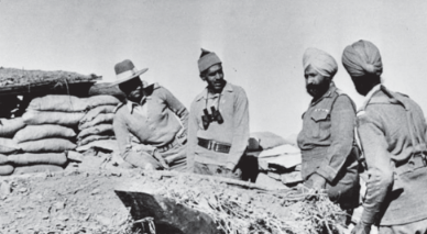
While the McMahon Line dominated the eastern sector, the western frontier presented a different but equally serious problem. Aksai Chin, a vast and sparsely populated plateau in the eastern part of the wider Ladakh region, became a major point of contention because of its location and strategic connectivity.
The region’s harsh climate and limited vegetation could make it appear remote from the concerns of ordinary life. Strategically, however, it was important because a road through Aksai Chin connected Xinjiang with Tibet. For China, that route strengthened communications between two sensitive regions under its control. For India, the road’s construction through territory it claimed represented a serious challenge to its sovereignty.
The dispute became more prominent during the 1950s as the two governments exchanged maps, diplomatic notes and competing explanations of their respective claims. The problem was aggravated by the lack of an agreed boundary on the ground. Each side increasingly relied on its own understanding of the frontier, making patrols and the establishment of posts potential sources of confrontation. In this environment, India adopted what became known as the Forward Policy in 1961.
Indian forces established additional posts in disputed areas in an attempt to prevent further Chinese advances and demonstrate India’s presence in territory it claimed. The policy reflected a determination not to surrender ground through inaction, but it also created serious operational difficulties.
The road to war: When diplomacy failed to contain the crisis
The months preceding October 1962 witnessed a deterioration in relations and increasing military tension along the frontier. Diplomatic exchanges continued, but they failed to bridge the differences over territorial claims. Meanwhile, both countries interpreted the other’s actions as evidence of hostile intentions. India’s Forward Policy sought to resist further Chinese consolidation in disputed areas. China, in turn, opposed Indian forward posts and warned against their continuation.
The situation became particularly tense in the eastern sector around the Dhola Post and the disputed Thag La area, where the precise alignment of the frontier was contested. Clashes and troop movements during September and early October heightened the risk of a larger confrontation. The crisis was no longer a distant diplomatic disagreement; forces were facing one another in difficult terrain, with limited room for manoeuvre and a growing possibility of escalation.
The offensive that began on 20 October was coordinated across the eastern and western sectors. In NEFA, Chinese forces struck Indian positions and advanced rapidly through the mountain approaches. In Ladakh, Chinese troops attacked Indian forward posts, exploiting their advantages in numbers, local logistics and the ability to concentrate forces. The speed and scale of the attacks revealed that India’s preparations were inadequate for the confrontation that followed. Political expectations of a limited border dispute had not been matched by sufficient military strength, logistical support or a coherent operational response.
The Indian Army was required to defend remote positions under conditions that severely restricted movement, communication and resupply. It is important, however, to distinguish between the sequence of events and the broader debate over responsibility. The boundary dispute, China’s strategic objectives, the Tibetan question, India’s Forward Policy and the decisions of both governments all contributed to the deteriorating environment. Historians continue to debate the relative weight of these factors, and a serious assessment must recognise the complexity of the crisis.
Nefa: The eastern front collapses
The eastern theatre became the most visible symbol of India’s military reverses. NEFA, administered at the time as a frontier agency and now largely part of Arunachal Pradesh, consisted of difficult mountainous terrain with limited road connectivity. Military operations depended heavily on narrow routes, animal transport, foot movement and air supply, all of which constrained the speed at which reinforcements and essential equipment could reach forward positions.
Chinese forces attacked Indian positions in the eastern sector on 20 October and quickly placed Indian troops under severe pressure. The offensive exploited the advantages of preparation, concentration and local mobility. Indian units, in many places thinly deployed and inadequately supported, struggled to hold positions against a better prepared assault. Tawang, an important centre in the eastern Himalayas, was captured by Chinese forces during the first phase of the campaign. The loss was strategically and psychologically significant because it demonstrated how quickly the situation had deteriorated. Indian troops subsequently faced further pressure as the offensive continued southwards.
Ladakh: The cost of isolated positions
In Ladakh, the war unfolded across a different geographical setting but revealed many of the same vulnerabilities. The region’s high altitude desert, severe cold, thin air and vast distances placed extraordinary demands on troops and transport. Posts were frequently separated by difficult terrain, while supplies and reinforcements depended on limited routes and air support. Chinese forces attacked Indian positions in the western sector on 20 October, overcoming several forward posts.
The operations were connected to the wider dispute over Aksai Chin and China’s efforts to secure its claimed territory and strategic communications. India’s deployment of forward posts had been intended to establish a visible presence in areas it claimed. Yet a post’s symbolic value could not substitute for its military defensibility. Positions that were difficult to reinforce or mutually support became vulnerable when the opposing side concentrated superior forces against them.
The conflict demonstrated the danger of pursuing a territorial policy without ensuring that the military possessed the resources and operational flexibility necessary to implement it. A strategy that relies on an adversary refraining from escalation is not a reliable substitute for preparedness. The lessons from Ladakh were therefore closely related to those from NEFA. Intelligence, logistics, mobility, equipment and command arrangements had to be considered as integral parts of national policy, rather than technical matters to be addressed after political decisions had been made.
The war also reinforced the strategic importance of infrastructure in the Himalayas. Roads, airfields, communications networks and supply facilities are not merely instruments of economic development in frontier regions; they determine how rapidly forces can be moved, how long they can remain in position and whether a government can respond effectively during a crisis.
The ceasefire and its consequences
The fighting continued through November, culminating in a second major Chinese offensive in the eastern sector. Chinese forces advanced further south, and the Indian military situation deteriorated sharply. On 21 November 1962, China announced a unilateral ceasefire, effective from midnight on 21–22 November, and declared that its forces would withdraw in the eastern sector to positions behind the line it had specified. The situation in the western sector remained different. The ceasefire ended the principal phase of the war, but it did not resolve the underlying boundary dispute.
China retained control of Aksai Chin, while India continued to administer NEFA, which later became the state of Arunachal Pradesh. The frontier remained unsettled, leaving a source of strategic friction that would continue to shape relations between the two countries. Why did China stop when its forces had achieved substantial battlefield gains? The answer involves more than one consideration. The difficulty of sustaining an advance across the Himalayas as winter approached, the challenge of maintaining extended supply lines and the prospect of greater international involvement all formed part of the strategic environment. India had also sought external military assistance as the scale of the crisis became clear.
The reckoning in new Delhi
The war forced India to reassess the relationship between diplomacy, political leadership and military power. Non-alignment remained an important principle of Indian foreign policy, but the conflict demonstrated that strategic independence required credible defence capabilities. A country could reject permanent military blocs while still developing the means to protect its territory and seek assistance when circumstances demanded it. Nehru’s national broadcast on 22 October captured the scale of the transformation.
He called for increased military strength and faster decision-making, while stressing that defence depended on the productive capacity of the wider economy. Industry, agriculture, savings and national mobilisation, he argued, all had a role in meeting the emergency.This was a significant recognition that national security cannot be separated from the economic foundations that sustain it. Soldiers require ammunition, clothing, food, transport, communications and equipment. These cannot be produced or delivered reliably without industrial capacity, financial resources, administrative competence and planning.
What 1962 means for India Today
The strategic environment has changed considerably since 1962, but several of the underlying challenges remain relevant. India and China continue to have unresolved boundary differences, and the Line of Actual Control is not mutually delineated in all sectors. Disagreements over the frontier therefore continue to create the possibility of patrol confrontations and military tension. The contemporary boundary must not be confused with the exact battlefield positions of 1962.
The Line of Actual Control is an operational concept describing the areas up to which the two countries exercise control, and its alignment is disputed in places. Nevertheless, the history of the war helps explain why both sides attach importance to deployments, infrastructure and the maintenance of a credible presence in frontier regions. The first lesson is the necessity of realistic intelligence assessments. Governments must evaluate an adversary’s capabilities, logistical preparations and strategic intentions rather than relying on assumptions about what the other side is likely to do.
Intelligence is valuable only when it is analysed critically, communicated effectively and incorporated into decisions. The second lesson is that military policy must be matched by military capability. Territorial claims, patrols and forward deployments carry risks when the forces responsible for them lack adequate reinforcement, equipment or logistical support. Deterrence depends not simply on the presence of troops but on the ability to sustain them and respond effectively if challenged.
Beyond remembrance
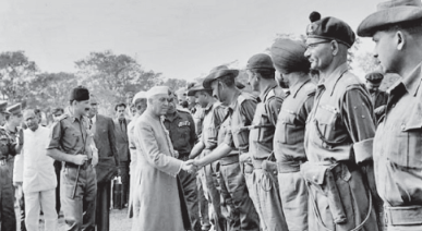
The significance of 20 October 1962 lies in the distance between the India that entered the crisis and the India that emerged from it. Before the war, the country placed considerable confidence in the possibility that political understanding could contain a difficult relationship with China. After the defeat, it had to confront the reality that unresolved territorial disputes, incompatible strategic interests and inadequate preparedness could combine to produce a military catastrophe.
The soldiers who defended isolated Himalayan positions faced conditions that no account of policy failure should diminish. Their experience also underscores the responsibility of the state to ensure that military personnel are equipped, supported and commanded in accordance with the tasks they are expected to perform. Remembering their sacrifice requires more than ceremony; it requires learning from the decisions that shaped their circumstances.