
DAY 1
A morning flight from Delhi brought us to Dehradun, where we met up with some of the groups that have also travelled on this flight. It was a very short flight and as we exited the airport, we are happy to see that there were very strict protocols that we had to pass through before we could leave. We had a long drive ahead of us and were soon off, on the road to Harsil, which was to be our night stop.


We could now see the wonderful visual of the spectacularly large Tehri Dam laid out between the hills around. The waters of the dam had spread out among the hills and lay between them and seemed as if it formed a gigantic lake. Next, we came to Nagun, where we had to report at a Police check post to show our certificates. We pass Maneri, which had a huge hydroelectric power project. After a final push, we reached our Hotel Prakruthi and were relieved to get out of the van and stretch our legs.
DAY 2
Trek Day 1
Drive to Gangotri 1 hour – Trek to Chirbasa
Altitude: 3580m/ 11745ft
Distance: 11.4 Km
Time taken: 6 hours
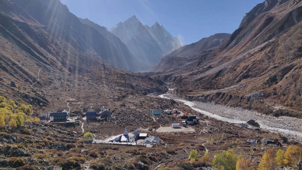
A beautiful morning and as we looked out of our windows, we saw the beautiful Bhagirathi River, very fast-flowing but not in spate. Above us were the mountains with the rays of the morning sun touching them. Good breakfast and we were into our vans, driving to Gangotri, a beautiful drive through the mountains. This is one of the Char Dhams, we spent a half-hour wandering about the temple area and after darshan at this beautiful little temple of Mother Ganga we were good to go.
On the opposite skyline, was the snow-covered peak of Mount Sudarshan, rising up white above the nearer mountains that are green, covered with trees. The River Bhagirathi flowed alongside the bank, with the temple facing east. We headed out of the temple complex and began climbing a long flight of steep steps that lead us to the path. Once on the path, we spread out and began climbing up following Kailash, who was heading the pack. We are soon at the entry point into the Gangotri National Park and our team leaders needed to stop in at this check post, to show papers and get clearances for the group to head out. A photo-op here with the Sudarshan mountain still forming the background.
DAY 3
Trek Day 2
Chirbasa to Bhojbasa
Altitude: 3,740 m/ 12,270 ft
Distance: 5 km
Time: 2-3 hours
A 6 am start for everyone and the breakfast tables were laid out in the midst of the pretty grove of trees. Tea to start the morning and a great healthy breakfast to follow; porridge with nuts, papaya, omelettes with toast—we ate it all, as we needed to fuel up for today’s trek to Bhojbasa, a distance of about 5 km that we have to cover.
We left the wooded area, climbed the steep winding path up to the check post and turned right and headed out on the path, leading away from the Chirbasa campsite. We were soon high above the Bhagirathi River, and we realized the entire trek today would be alongside the river. The sound of the river is rather muted now in this area.
To the left of us were mountains, and to the right, an astounding sight of tall snow-covered mountains, and their peaks. In front we had the majestic, snow-covered Mount Sudarshan and down below was the Bhagirathi River tumbling over rocks as it flowed down the mountain towards Gangotri. We could hear the gentle roar of the river that would stay with us all day. There were areas where the path had moved further away from the River, and then it became a muted sound.
DAY 4
Trek Day 3
Bhojbasa to Tapovan
Altitude: 4,400 m/ 14,566 ft
Distance: 6 km
Time: 5-6 hours
We set off after breakfast and then discovered that we had a long wait to get a turn with the unending line of trekkers and others trying to get across the river. Finally, we were all across the river and on the other bank and we headed out on the path following our guides.
There were very slippery areas that we had to use our poles to get us through, and then a narrow gap between giant rocks that we had to edge our way through. It was cold outside and had begun to snow as well. Our porters carrying all our tents were nowhere to be found, as they had not reached up the mountain yet. There was a bit of a dilemma as to where 24 of us would go in this extremely cold and windy place.
DAY 5
Trek Day 4
Tapovan to Meru Glacier
Altitude: 4,800 m/ 15748 ft
Distance: 2.9 km
Time: 2 hours
We woke up to a bright sunny day and it was very cold out there. We were happy to see our camp getting set up. It was on the beautiful meadow way below us and it was a welcoming sight. Tea was brought up to us and after that, we headed down to the campsite, where the red sleeping tents were almost ready and the toilet tents had been set in a straight line, a short distance away.
The visuals around us were almost overwhelming as we were surrounded by the most magnificent mountains of that region. The three Bhaghirathis, Mount Meru and the magnificent Mount Shivling. The early morning rays of the sun touched the top of Shivling first, bathing the peak in a golden light. It is heart-stopping and stunning and we saw this and it silenced us. Mount Meru’s distinctive ‘shark fin’ is also clearly visible to us. We were at an altitude of over 4800m in that desolate meadow that seemed to stretch out forever before us. As we looked around at these beautiful visuals, we realized that right there before us were the very reasons why we trek in mountains around the world. It was a humbling feeling
At the Ridge above the Meru Glacier
The climb down was equally tough but seemed much quicker. As we climb down, we were suddenly through the rough, stony path and were headed down a gentler slope and then finally we are out on the meadow. As we walked towards the camp it was hard not to be overwhelmed by the mountains surrounding us on all sides. It was humbling to be in the midst of these awe-inspiring mountains and we realized how insignificant we really were.
DAY 6
Trek day 5
Tapovan to Gaumukh to Bhojbasa
Distance: 6.6 km
Altitude: 3740m/ 12270ft
Time: 5 hours
A bitterly cold night had all of us shivering in our sleeping bags and tents as the night temperatures would have been well below zero. When we woke up in the morning our tents were totally frozen. There was frost on the ground and it covered our tents as well, in white, powdery flakes, that fell, even inside as we unzipped our tents in the morning for the first time!
Surrounded by mountains on all sides, with the three Bhagirathis, creating a background for our walk down to the Bhojwassa crossing. It was a short climb again and we reached our lunch spot among the rocks, where we had stopped a couple of days earlier. There were tall lavender fringed stems in the middle of all these bushes that are maroon, yellow and shades of green. It was as they say a vista to behold!
DAY 7
Trek Day 6
Bhojbasa to Gangotri
Drive: Gangotri to Dharali
Distance: 11 km
Altitude: 3415m / 11204ft
Time: 6 hours
This beautiful trail hugged the side of the mountain and it was the very same path that we had hiked on five days ago. We could see it following the edge of the mountain taking the curves as it went along. The Bhagirathi River had been a continuous presence throughout our trek every day, and we saw it down below us, tumbling over the rocks as it made its way down the mountains. We could hear the roar of the water echoing up through the silence all around us. Often, we found the need to stop and just look around at the beauty all around us.
The challenges that we face every day, while walking and climbing are so satisfying, as the terrain is rough, altitudes are high and the paths are sometimes fraught with danger. There is a feeling of immense satisfaction at the end of every trek.